Hurricane Wilma
| Category 5 hurricane (SSHS) | ||
|---|---|---|
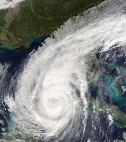
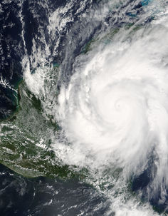 Hurricane Wilma at record intensity southeast of the Yucatán Peninsula on October 19, 2005 |
||
| Formed | October 15, 2005 | |
| Dissipated | October 26, 2005 | |
| Highest winds |
|
|
| Lowest pressure | 882 mbar (hPa; 26.05 inHg) (Record low in Atlantic) |
|
| Fatalities | 23 direct, 39 indirect | |
| Damage | $29.1 billion (2005 USD) $32.6 billion (2010 USD) |
|
| Areas affected |
Jamaica, Haiti, Cayman Islands, Cuba, Honduras, Nicaragua, Belize, Yucatán Peninsula, Florida, Bahamas, Atlantic Canada | |
| Part of the 2005 Atlantic hurricane season |
||
Hurricane Wilma was the most intense hurricane ever recorded in the Atlantic basin. Wilma was the twenty-second storm (including the subtropical storm discovered in reanalysis), thirteenth hurricane, sixth major hurricane, and fourth Category 5 hurricane of the record-breaking 2005 season.
Wilma made several landfalls, with the most destructive effects felt in the Yucatán Peninsula of Mexico, Cuba, and the U.S. state of Florida. At least 63 deaths were reported, and damage is estimated at over $29.1 billion ($20.6 billion in the US; 2005 US dollars),[1] ranking Wilma among the top 5 costliest hurricanes ever recorded in the Atlantic and the fourth costliest storm in U.S. history.
Contents |
Meteorological history
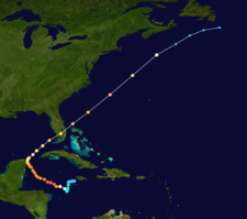
A large area of disturbed weather developed across much of the Caribbean Sea from an upper-level low across the southwestern Atlantic Ocean. A broad area of low pressure developed on October 13 to the southeast of Jamaica, and slowly became more concentrated as upper-level wind shear gradually decreased. Dvorak classifications began on October 14, and by late October 15 the surface circulation in the system became well-enough defined, with sufficiently organized deep convection, for the National Hurricane Center to designate the system as Tropical Depression Twenty-Four while located about 220 miles (345 km) east-southeast of Grand Cayman.[1]
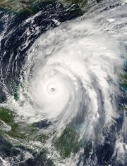
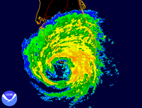
The depression drifted southwestward because of the influence of two ridges to its north, and with warm water temperatures and a favorable upper-level environment it strengthened into Tropical Storm Wilma on October 17. Initially, development was slow, due to the large size of the storm and a flat pressure gradient. However, convection gradually organized, and from October 18 through the 19th Wilma underwent explosive deepening over the open waters of the Caribbean. In a 30- hour period, the pressure dropped from 982 mbar to the record-low of 882 mbar, while the winds increased to 185 mph (295 km/h).
Wilma weakened below category 5 intensity on October 20 to 150 mph (130 knots) due to an eyewall replacement cycle and began to turn towards the northwest and further decreased in forward speed. The once tiny 2 n mi eye was replaced by a 40 n mi eye. Late on October 21 Wilma made landfall on the island of Cozumel at around 2145 UTC with maximum sustained winds of 150 mph and then again made a second landfall on the Mexican mainland 6 hours later and only slightly weaker.[1]
Wilma continued to slowly drift towards the north over the Yucatan peninsula, although it weakened to a moderate hurricane while over land, it reemerged over the southern Gulf of Mexico on October 23 around 0000 UTC. Despite Wilma spending 24 hours over land it reemerged completely intact and began to re-intensify shortly after. This was perhaps due to its large size and because the majority of its circulation remained over the warm waters of the NW Caribbean and Gulf of Mexico. A powerful trough turned the hurricane to the northeast and accelerated its forward motion. Its large eye remained well-organized, and Wilma intensified despite increasing amounts of wind shear, briefly producing winds of 125 mph (200 km/h) before hitting Cape Romano, Florida as a 120 mph (195 km/h) major hurricane (although maximum sustained winds at the Florida landfall, according to some sources, might have been stronger)[2]
[3]. Wilma crossed the state in about 4.5 hours and weakened to winds of 110 mph (175 km/h) after entering the Atlantic Ocean near Jupiter, Florida. Key West received several feet of water in the low-lying areas and flooded homes. The Lower Keys also experienced an unusual flood: it occurred twice. First, as the storm crossed toward Florida it pushed water across the keys from south to north. As the storm finally crossed into the Everglades, all the water that had been pushed by the storm was released as Wilma crossed the peninsula. The water then raced back across the Lower Keys a second time and went back out to sea. This caused additional flooding and costly damage. Possibly due to less friction of the eyewall or moving over warm waters of the Gulf Stream, Wilma again re-intensified to reach winds of 125 mph (200 km/h) before cold air and wind shear penetrated the inner core of convection. On October 26 it transitioned into an extratropical cyclone, and the next day the remnants of Wilma were absorbed by another extratropical storm over Atlantic Canada.[1]
Preparations
Mexico
Quintana Roo government officials declared a red alert on the evening of Wednesday, October 19. Classes were suspended in the state's northern municipalities and residents of coastal areas were advised to take refuge further inland; tourists in the resort city of Cancún and its adjacent islands were told to return to their places of origin or head inland while those unable to were relocated to designated hurricane shelters throughout the city. In neighboring Yucatán, classes were also suspended in 18 coastal municipalities.[4]
Central America
In Nicaragua, civil organizations were ordered to make hurricane preparations, while in El Salvador, the National Emergency Committee was activated.
Cuba
In Cuba, preparations were made to evacuate four western provinces, including the Isle of Youth.[5] In all, over 760,000 people were ordered to evacuate.[6]
Florida
A mandatory evacuation of residents was ordered for the Florida Keys in Monroe County and those in Collier County living West or South of US 41.[7] County offices, schools and courts were closed Monday, October 24. At least 300 Keys evacuees were housed at the Monroe County shelter at Florida International University in Miami-Dade County.[8] All Collier County public schools were declared closed for Friday, October 21. The schools were closed to "allow parents and staff to prepare for the storm and potential evacuation", and also allowed "for needed preparation of schools to be used as hurricane shelters." The schools remained closed on Monday, October 24, as the hurricane made landfall.[9] Schools around Fort Myers and Tampa, as well as Sumter, Marion, Pasco, and Polk counties, were closed on Monday, October 24. Schools in Palm Beach and Broward counties were closed for two weeks because of extended power outages and some damage to school buildings. Schools in Collier and Miami-Dade counties were closed for a little over a week, including the University of Miami.
Orange juice futures reached the highest level in six years on Wednesday, October 19, 2005, closing up 2.9 cents at $1.118 per pound.[10] As dynamic models moved the storm's track east over Florida, oil futures eased as worries of another direct hit on the oil-producing regions of the Gulf of Mexico subsided. College and professional hockey games scheduled the weekend before Wilma's landfall were rescheduled for a later time. The professional football game scheduled for Sunday was moved ahead to Friday night. A concert by the industrial rock band Nine Inch Nails, expected to have taken place Monday, October 24, was postponed and later cancelled. Key West's Fantasy Fest held around each Halloween was postponed until December.
Impact
| Region | Deaths | Damage (2005 USD) |
|---|---|---|
| Direct (Indirect) | ||
| The Bahamas | 1 | $100 million |
| Cuba | 0 (4) | $700 million |
| Haiti | 12 | $500,000 |
| Jamaica | 1 | $93.5 million |
| Mexico | 4 (4) | $7.5 billion |
| United States | 5 (31) | $20.6 billion |
| Total | 23 (39) | $29 billion |
Wilma was responsible for at least 63 total deaths and over $29 billion (2005 USD) in damages.
Caribbean
In Haiti, the outer bands of Wilma triggered mudslides, killing at least 12 people.[11] Damage in the country totaled around $500,000 (2005 USD).[12]
Wilma claimed one death in Jamaica as a tropical depression on October 16. It pounded the island for three days ending on October 18, flooding several low-lying communities and triggering mudslides that blocked roads and damaged several homes. Almost 250 people were in emergency shelters on the island.[13] Damage on the island totaled $93.5 million (2005 USD).[14]
Mexico
At least eight deaths were reported in Mexico. Five were in the Playa del Carmen area due to a gas explosion caused by the strong winds. Four deaths also were reported in Cozumel and another in Cancún due to wind blowing a window out. Another death, caused by a falling tree, was reported in the state of Yucatán.[15]

Pictures and television reports indicated extensive structural damage throughout the Cancún area, as well as significant flooding and many downed trees, power lines and scattered debris. Several homes had also collapsed. Rainfall amounts in excess of 23 inches (590 mm) were reported in several areas, with Isla Mujeres reporting 64 inches (1637 mm)—five times what Hurricane Gilbert dropped.[16] One gymnasium used as a shelter lost its roof, which forced the evacuation of more than 1,000 people staying there.[15] During the storm, waves five to eight meters high (enough to reach the third floor of many hotels) slammed against the coastline.[17] Damage was extensive as well on Cozumel, with many broken windows, fallen trees and power lines, but less structural damage. It was comparable to the scene after Hurricane Emily back in July 2005, a storm of similar intensity at landfall, but faster moving.
The governor of Quintana Roo, Félix González Canto, said in an interview: "Never in the history of Quintana Roo have we seen a storm like this."[18]
Communication was initially limited, as telephone and electric services were completely out in the affected areas; however, in downtown Cancún, some telephone communications remained intact, and tourists went out and risked their lives to contact home. There were also extensive reports of looting of many businesses in Quintana Roo, particularly in Cancún.[15]
After Wilma passed, a sense of desperation developed in the region because people were being held in shelters due to the extensive damage. Thousands of tourists remained stranded in shelters, and the priority was to send them home immediately, according to President Vicente Fox. Buses arrived in Cancún from Mérida, where tourists were hoping to find flights home. The United States embassy told tourists to go to Mérida, although the next day they had to change their announcements because Mérida had become so packed with people. The road to Mérida was very dangerous and practically impassable for taxis, yet people dealt with the exorbitant fees being charged for passage.[19]
The destruction left behind by Wilma in the Yucatán severely damaged the tourist industry there, as the storm affected some of the tourist hot spots of Mexico. Damage in Mexico totalled $7.5 billion (2005 USD, $80 billion 2005 MXN), of which $4.6 billion (2005 USD, $50 billion 2005 MXN) was from agricultural damage.[20]
Cuba
In Cuba, a bus carrying evacuees crashed, killing four people, including three foreign tourists.[21]
Coastal flooding caused by Wilma's storm surge and flooding from the outer bands was reported in many areas, particularly around Havana. More than 250 homes were heavily flooded and rescuers required scuba gear, inflatable rafts and amphibious vehicles to reach the most severely flooded areas.[22] Havana was also without power and wind damage was reported as a result of winds up to 85 mph (140 km/h).[23] Officials in Cuba estimated total damage to be about $700 million.[6]
United States
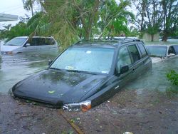
At least five hurricane-related deaths were reported in the United States, all in Florida, and there were at least 26 deaths indirectly related to Wilma.[24][25] Damage from Wilma was extensive and widespread over South Florida due to winds and flooding. After the hurricane had passed, a storm surge from the backwash of up to 8 ft (2.4 m) from the Gulf of Mexico inundated a large portion of the lower Keys.[26] The peak of the storm surge occurred when the eye of Wilma had already passed over the Naples area, and the sustained winds during the surge were less than 40 mph (64 km/h).[27]
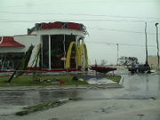
Hurricane Wilma caused widespread destruction of critical infrastructure, including power, water and sewer systems. Florida Power and Light, the largest electricity utility in the state, reported more than 3,241,000 customers had lost power,[28] equivalent to approximately 6,000,000 people, with most residents getting power restored in 8–15 days. Running water was restored for most residents within 2 days. Broward and Palm Beach counties were hit particularly hard by the many tornadoes in the western portion of the hurricane.[1] Most notably in downtown Fort Lauderdale, there was significant damage to older buildings, including the Broward County Courthouse, School Board Building and taller area office buildings built before the implementation of stricter building codes after Hurricane Andrew. The glass facades in a number of downtown buildings, notably the Templeton Building, were sheared off by high winds. Damage in Florida totaled $20.6 billion (2005 USD).[29] As of 2009, there are still people waiting for insurance settlements and repairs on their homes in Dade and Broward counties.
Bahamas
While passing the Bahamas, the hurricane produced hurricane force winds[30] and a powerful storm surge, flooding southwestern coastal areas of Grand Bahama and destroying hundreds of buildings. In western settlements on the island of Grand Bahama, graves were washed up with skeletal remains lying in the streets. Damage totaled about $100 million (2005 USD, $105 million 2007 USD), almost entirely on the western half of the island. The central portion of Grand Bahama, including in and around Freeport, reported minor to moderate damage, while the eastern end received little to no damage.[31] One child died on the island from the flooding. Elsewhere in the Bahamas, moderate damage occurred on Bimini[32] and Abaco,[33] while islands farther to the south reported minimal wind damage.[32]
Wilma struck the Bahamas during the filming of Disney's Pirates of the Caribbean: Dead Man's Chest. The service roads were destroyed and several trailers turned over. The two principal ships, the Black Pearl and The Flying Dutchman, were relatively undamaged and the cast and crew were evacuated on the Friday before the hurricane hit.[34]
Aftermath
United States
Florida's sugar industry was hard hit; the cropping season had already started and had to be halted indefinitely. Damage to sugarcane crops was critical and widespread. Citrus canker spread rapidly throughout southern Florida following Hurricane Wilma, creating further hardships on an already stressed citrus economy due to damage from Wilma and previous years' hurricanes. Citrus production estimates fell to a low of 158 million boxes for the 2005-2006 production season from a high of 240 million for 2003-2004.[35]
In March 2006, the National Weather Service opened its new hurricane and weather forecasting center at 1315 White Street in Key West. The center is designed to withstand a Category 5 hurricane and associated storm surge. It had been under construction during the 2005 hurricane season. In January 2006 artists were invited to exhibit sculptures inspired by the storm in an outdoor exhibit at Fort Zachary Taylor in Key West.
Mexico
The popular Mexican resort towns of Playa del Carmen, Cozumel, and Cancún all suffered significant damage from Wilma, causing major loss of tourism income. The MTV Video Music Awards Latin America 2005 were to be held Wednesday, October 19, 2005 at the Xcaret Eco Park (close to Cancún) in Quintana Roo, Mexico. The 2005 edition of these awards was postponed, however, due to the approach of Hurricane Wilma toward the Mexican Riviera Maya. MTV had moved the date from October 20 to October 19 in an attempt to avoid Hurricane Wilma, but eventually decided to cancel the show.
Cuba
The United States offered emergency aid to Cuba, and to the surprise of the State Department, the Cuban government accepted. Many times in the past, including during Hurricane Dennis, the U.S. offered aid, but the Cuban government declined. The State Department sent three damage assessors to Havana to determine their needs.[36]
Retirement
Due to significant damage in Mexico and Florida, the name Wilma was officially retired in April 2006 by the World Meteorological Organization, and will never be used for an Atlantic storm again. It was replaced by Whitney on List III of the Atlantic hurricane naming lists which is used next in the 2011 season.[37]
Records and naming
| Most intense Atlantic hurricanes | |||||
|---|---|---|---|---|---|
| Rank | Hurricane | Season | Pressure | ||
| hPa | inHg | ||||
| 1 | Wilma | 2005 | 882 | 26.0 | |
| 2 | Gilbert | 1988 | 888 | 26.2 | |
| 3 | "Labor Day" | 1935 | 892 | 26.3 | |
| 4 | Rita | 2005 | 895 | 26.4 | |
| 5 | Allen | 1980 | 899 | 26.5 | |
| 6 | Katrina | 2005 | 902 | 26.6 | |
| 7 | Camille | 1969 | 905 | 26.7 | |
| Mitch | 1998 | 905 | 26.7 | ||
| Dean | 2007 | 905 | 26.7 | ||
| 10 | "Cuba" | 1924 | 910 | 26.9 | |
| Ivan | 2004 | 910 | 26.9 | ||
| Source: HURDAT[38] | |||||
The storm was named "Wilma," the first time the 'W' name was used in the Atlantic Basin since alphabetical naming began in 1950. With Wilma, the 2005 hurricane season broke the record for most storms in a season previously held by the 1933 season. Moving slowly over warm water with little wind shear, Wilma strengthened steadily and became a hurricane on October 18. The 13th hurricane of the season, Wilma broke the record set in 1969 for most storms of hurricane strength in one season for the Atlantic Basin. The pressure measured in Wilma, 882 mb, is currently the lowest recorded pressure for a tropical cyclone in the Atlantic Basin, as well as the lowest pressure for any cyclone measured in the Western Hemisphere. It also reached its 882 mbar pressure in a span of 24 hours, making it the fastest pressure drop of any storm in the Atlantic Basin, although Hurricane Felix of 2007 reached a greater windspeed rise in 51 hours. At its peak intensity, the eye of Wilma was about 3 miles (5 km) in diameter, the smallest known eye of an Atlantic hurricane.[1] In Mexico, Isla Mujeres reported 64 inches (1637 mm) of rainfall—five times what Hurricane Gilbert dropped. This set a 24-hour rainfall record for the country of Mexico, and was the highest point total for rainfall from a tropical cyclone since Hurricane Mitch in 1998. It was the costliest Atlantic hurricane in Mexico, and the second costliest natural disaster in Mexican history, behind only Hurricane Pauline of the 1997 Pacific hurricane season, which did $8.84 billion worth of damage.[20]
Wilma was the first retired "W" name since the World Meteorological Organization started retiring names in 1954, it was the strongest Atlantic hurricane to be retired, and when it was retired, it made 2005 the season with the most retired names, with 5; the old record was a three-way tie with 4 names retired in 1955, 1995, and 2004. Wilma was replaced with the name Whitney. Had the unnamed 2005 Azores subtropical storm been operationally recognized it would have been named Subtropical Storm Tammy, and storms forming after October 4 would have been moved one name down the list. Wilma would have consequently been given the name Alpha, in accordance with the convention to name tropical cyclones after the Greek alphabet if the scheduled list of names runs out.[39][40]
See also
- List of Atlantic hurricanes
- List of Category 5 Atlantic hurricanes
- List of natural disasters in Haiti
- List of 2005 Atlantic hurricane season storms
- Tropical Storm Wilma
- Timeline of the 2005 Atlantic hurricane season
- List of Florida hurricanes (2000–present)
References
- ↑ 1.0 1.1 1.2 1.3 1.4 1.5 Richard J. Pasch, Eric S. Blake, Hugh D. Cobb III, and David P. Roberts (January 12, 2006). "Hurricane Wilma Tropical Cyclone Report". National Hurricane Center. http://www.nhc.noaa.gov/pdf/TCR-AL252005_Wilma.pdf. Retrieved 7 May 2010.
- ↑ "Wilma devastates Florida with winds over 125 mph winds speeds". The Michigan Daily. October 24, 2005. http://www.michigandaily.com/content/wilma-devastates-florida-winds-over-125-mph-winds-speeds. Retrieved 7 May 2010.
- ↑ (February 10, 2008) Hurricane Wilma archive. (Report). Retrieved May 18, 2009.
- ↑ Hernandez, Silvia (Wednesday October 19, 2005). "El Universal: Preparan alerta roja en Quintana Roo (Spanish)". El Universal. http://www.el-universal.com.mx/notas/311317.html. Retrieved 7 May 2010.
- ↑ "Hurricane Wilma grows in strength". BBC News. October 19, 2005. http://news.bbc.co.uk/2/hi/americas/4352192.stm. Retrieved 7 May 2010.
- ↑ 6.0 6.1 "Hurricane Wilma exacts losses of 704 million dollars: Cuban government". ReliefWeb. November 28, 2005. http://www.reliefweb.int/rw/RWB.NSF/db900SID/NKUA-6JKMYU?OpenDocument. Retrieved 8 May 2010.
- ↑ WBBH NBC-2 Collier County issues evacuations
- ↑ Monroe County, Florida: Emergency Bulletins
- ↑ Collier County Public Schools
- ↑ Weather News AccuWeather.com (link dead)
- ↑ "Yahoo News: Hurricane Wilma intensifies, turns deadly in Haiti", October 19, 2005
- ↑ Université Catholique de Louvain (2007). "EM-DAT: The OFDA/CRED International Disaster Database for the Caribbean". http://www.em-dat.net/. Retrieved 2007-09-07.
- ↑ NDTV: Wilma nears Cayman Islands
- ↑ Norman Harris (2006). "The Use of Nowcasting Technology for Natural Hazard Mitigation: The Jamaican Experience" (PDF). World Meteorological Organization. http://www.wmo.ch/pages/prog/amp/pwsp/documents/Jamaica_Nowcasting.pdf. Retrieved 2008-11-16.
- ↑ 15.0 15.1 15.2 "Hurricane Wilma kills at least 7 in Mexico", Associated Press, October 23, 2005
- ↑ Hydrometeorological Prediction Center. Hurricane Gilbert (1988) Storm Total Graphic. Retrieved on 2007-01-26.
- ↑ El Universal. Wilma: Anticipan 30 horas más de huracán. Retrieved on 2007-04-22.
- ↑ "Hurricane Wilma Punishes Mexican Coastline", Associated Press, October 23, 2005
- ↑ Sun Sentinel. Headlines. Retrieved on 2007-01-26.
- ↑ 20.0 20.1 Servicio Meteorologico Nacional. Ciclones. Retrieved on 2007-01-26.
- ↑ "Wilma pounds Florida, floods Cuba, kills 15", Yahoo UK News, October 24, 2005
- ↑ "Wilma Barrels Across South Florida", Associated Press, October 22, 2005
- ↑ Wilma pummels Florida
- ↑ "Three confirmed dead in Collier; President Bush to visit Thursday". http://www.bonitanews.com/news/2005/oct/26/three_confirmed_dead_collier_president_bush_visit_/.
- ↑ "Hurricane Wilma Death Toll Rises To 14". http://www.nbc6.net/weather/5191015/detail.html?rss=ami&psp=news.
- ↑ Key West Citizen "Flooded cars litter the Keys" October 27, 2005
- ↑ Key West Citizen October 25, 2005 pp 1-2, 6
- ↑ "Annual Global Climate and Catastrophe Report: 2005" (PDF). AON Reinsurance Services. 2005. http://www.aon.com/about/publications/pdf/issues/2005_global_climate_catastrophe_report.pdf. Retrieved 2007-06-02.. p.33.
- ↑ National Hurricane Center. Hurricane Wilma. Retrieved on 2007-01-26.
- ↑ Jeff Masters (2005). "Update on Hurricane Wilma — October 24, 2005". http://www.hurricane-wilma.net/commentary_from_hurricane_experts/index.html. Retrieved 2007-02-20.
- ↑ Amy Royster (2005-12-04). "Wilma's Waves Devastate Grand Bahama Communities". Palm Beach Post.
- ↑ 32.0 32.1 International Federation of Red Cross And Red Crescent Societies (2005). "Caribbean: Hurricane Wilma Emergency Appeal No. 05EA024". ReliefWeb. http://www.reliefweb.int/rw/RWB.NSF/db900SID/KKEE-6HJLKT?OpenDocument&rc=2&cc=bhs. Retrieved 2007-02-18.
- ↑ Kevin Deutsch (2005-11-01). "Islanders Assess Damage After Sea Takes Homes". Palm Beach Post.
- ↑ Ted Elliott. "MOVIES Message Board — ARCHIVE 7". Wordplay Forums. http://www.wordplayer.com/forums/moviesarc07/index.cgi?read=83160. Retrieved 2006-07-09.
- ↑ 1-2 Punch Hits Citrus
- ↑ "Cuba Agrees to Accept U.S. Hurricane Aid". http://www.newsmax.com/archives/articles/2005/10/27/141009.shtml.
- ↑ "Dennis, Katrina, Rita, Stan, and Wilma "Retired" from List of Storm Names." NOAA. March 25, 2006.
- ↑ Staff Writer (2010-03-01). "Atlantic hurricane best track (Hurdat)". National Hurricane Center. National Oceanic and Atmospheric Administration. http://www.nhc.noaa.gov/tracks1851to2009_atl_reanal.txt. Retrieved 2010-03-20.
- ↑ Bob King (2006-04-11). "Wilma should've been Alpha". Palm Beach Post. http://www.palmbeachpost.com/storm/content/shared-blogs/palmbeach/storm/entries/2006/04/wilma_should_ha.html. Retrieved 2008-08-11.
- ↑ Neal Dorst (2007-05-08). "What happens if they run out of names on the list?". Atlantic Oceanographic and Meteorological Laboratory. http://www.aoml.noaa.gov/hrd/tcfaq/B6.html. Retrieved 2008-08-17.
External links
- Tropical Cyclone Report on Hurricane Wilma.
- The NHC's archive on Hurricane Wilma.
- Storm chaser George Kourounis documents the eye of Hurricane Wilma
- U.S. Rainfall for Hurricane Wilma from HPC
- Wilma pictures, satellites images
- The Disaster Center's Coverage of Hurricane Wilma
|
||||||||||||||||||||||||||||||||||
|
||||||||||||||||||||
|
||||||||||||||||||||||||||
|
|
|||||||||||||||||||||||||||||||||||||||||||||||